PEP will lead scientifically informed, proactive efforts by local communities that can reduce the negative impacts of climate change.
Share:
The influence of climate change on the Peconic Estuary and its surrounding communities will grow profoundly far into the future. Scientifically informed, proactive efforts can reduce the negative impacts.
Projected changes in precipitation patterns, particularly increases in extreme rain events, will likely cause greater runoff of nutrients and other pollutants from land into the Estuary and may also increase atmospheric deposition of pollutants. Rising sea levels are expected to result in increasingly frequent inundation of drinking water wells and septic systems on coastal properties, leading to more nitrogen and pathogens entering groundwater, surface waters, and the Estuary. In turn, greater nitrogen loading of the Peconic Estuary can be expected to result in more frequent harmful algal blooms, reduced water clarity, and a general degradation of coastal habitats. Excessive pathogens may lead to more frequent closures of bathing beaches and shellfish harvesting areas, while herbicides and pesticides are increasingly being linked to losses of seagrasses and other marine habitats that serve as important feeding and nursery areas for recreationally and commercially important fish species.
As temperatures increase, sea levels rise (SLR), and precipitation occurs with increasing intensity, estuarine species and habitats may move or change. Where there is significant coastal development and shoreline hardening, important habitats such as salt marshes could be blocked from migrating landward as sea levels rise. Changes in air and water temperatures may lead to shifts in the relative abundance of fish and other estuarine species. Species once thought to be more southerly or warm-adapted may become more common, while those adapted to cooler climatic conditions may decline. Ocean and coastal acidification due to increased atmospheric carbon dioxide could negatively affect shell-building creatures and many other types of estuarine life. The dynamic nature of the Peconic Estuary’s natural resources will require protection of critical habitats both where they exist today and where they may exist in the future.
Conservative projections for the Long Island region include air temperature increases ranging from 3°F to 6.6°F by 2050, along with greater temperature variability, increased seasonality, and higher frequency of extreme temperature events. Ocean temperatures in our region are expected to rise between 4°F and 8°F over the next century.
Precipitation
While increases in annual precipitation are expected to be relatively minor, the amount of precipitation falling as part of an "extreme" precipitation event and the frequency of such events is expected to increase, an increase in total rainfall of 1% to13% by 2050—periods of drought are also expected to increase.
Sea Level Rise
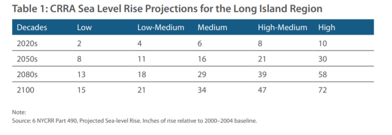
Globally sea levels are rising in part due to expansion of oceanic waters as average temperatures increase and in part due to increased amounts of available freshwater from melting glaciers and land-based ice. Locally, sea level is expected to increase up to 8 inches by the 2020s, and up to 30 inches by the 2050s. Rising seas are likely to causes stresses on habitat, human populations and natural resources. As sea level increases, we may expect an increase in demand for hardened shorelines. An environmentally beneficial alternative to hardening shorelines is construction of living shorelines which may also have positive impacts on habitat.
Ocean Acidification
As an increasing amount of carbon dioxide (CO2) accumulates in the atmosphere, there is a similar increase in the amount of CO2 that is transmitted to the oceans. When CO2 dissolves in salt water a series of chemical reactions take place that result in a decrease in the overall pH of the water, meaning that the water becomes more acidic. The process is called ocean acidification. The ocean pH is now lower than any time in the last 420,000 years and if current trends continue, the average pH of the oceans could drop by as much as 0.5 pH units relative to preindustrial levels.
Water Quality and Watershed
The Peconic Estuary’s surface waters support valuable habitat, recreation, and fisheries. Groundwater is the primary source of drinking water for the surrounding communities and freshwater for the watershed’s river, ponds, wetlands, and the Estuary itself. It also maintains the estuary’s saline balance.
The watershed’s surface water and groundwater, which are monitored and protected closely, face numerous pressures. Nutrients in groundwater (primarily from septic systems); contaminated runoff from impervious surfaces, lawns, agricultural areas, and golf courses; and atmospheric deposition of nitrogen have affected the Peconic Estuary’s water quality. Changes in precipitation patterns, in particular the projected increases in total precipitation and extreme rain events, will likely lead to increased land based runoff of nutrients, herbicides, and pesticides and may also lead to increased atmospheric deposition. Additionally increases in sea level will likely result in regular inundation of septic systems in coastal communities, either through regular tide cycles or elevation of groundwater level. This will lead to increases in the amount of nitrogen and pathogens transmitted directly to estuarine waters.
Nitrogen pollution is one of the most serious threats to the water quality of the Peconic Estuary, the main cause of hypoxia and HABs, and a contributing factor in the loss of critical eelgrass and wetland habitats.
Groundwater pumping has caused saltwater intrusion and reduced discharges to streams, ponds, coastal wetlands, and estuaries. Climate change has the potential to exacerbate these issues in the following ways:
Changes in precipitation—especially the projected increases in total precipitation and extreme rain storms—will likely lead to increased land-based and atmospheric inputs of nutrients.
Increased nutrient inputs plus warmer water may lead to more HABs, eutrophication, and hypoxia in salt and fresh surface water. The many impacts of climate change are likely to directly influence the occurrences, types, abundance, distribution and duration of harmful algal blooms in Peconic Estuary waters. Increased nutrient loading to the waters of the Peconic Estuary will provide more food for harmful algal blooms. Additionally, since harmful algal booms generally occur during the warm summer season, increasing water temperatures may result in earlier and more frequent blooms. Warming temperatures could also prevent mixing of the water, and allow the algae to grow thicker and faster.
SLR will likely result in the regular inundation of septic systems in coastal communities—either through higher tides or elevated groundwater levels—which could increase the amount of nitrogen and pathogens transmitted directly to estuarine waters.
SLR has the potential to change the depth of the interface between freshwater and saltwater, which would threaten Long Island’s drinking water supply and the Peconic Estuary’s freshwater-fed habitats.
Marine Habitats
Climate change is linked to the loss of eelgrass, wetlands, and other marine habitats, which provide an important feeding and nursery habitat for recreational and commercial fisheries.
Wetlands
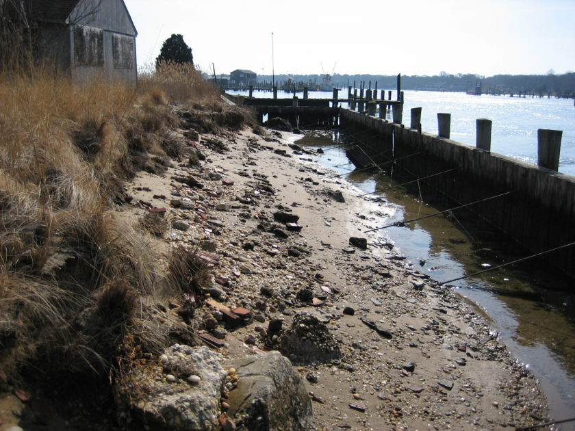
Wetlands can migrate inshore gradually with rising water levels. However, the rate at which the sea-level is rising is making it difficult for wetlands to migrate inshore fast enough. In many cases around the Peconic Estuary low marsh plants are not able to hold their ground and high marsh plants are becoming more dominant in wetlands. In areas with significant coastal development and shoreline hardening, coastal habitats will be prevented from migrating landwards as sea level rises.
Large areas of wetlands have been protected by municipalities and preservation stewards because they are important to commercial and recreational fishing and as nurseries for aquatic species. Because of their ability to absorb storm energy, wetlands are increasingly seen as a first line of defense against storm surge, adding to their value in land preservation.
Although wetlands can migrate inshore with rising waters , several factors can affect their migration, including the rate of SLR, shoreline type, sedimentation rates, and property development.
Narrow coastal areas can block migration pathways in nearshore
areas. Without sufficient sediment supply, SLR may drown low marsh wetlands if migration pathways are blocked and wetlands are prevented from migrating landward as sea level rises.
Eelgrass
Research suggests that rising water temperatures and reduced water clarity are contributing to the loss of eelgrass beds.
Eelgrass is often used as an indicator of estuarine health and water quality. Commonly found in shallow areas of high light penetration, eelgrass is already affected by water quality issues, harmful algal blooms, and boating. Eelgrass may be critically stressed by SLR-induced changes in salinity, water temperature, and ultraviolet radiation if protection measures are
not implemented.
Species Diversity and Populations
The great variety of habitats in the watershed supports diverse plant and animal species and populations. Rising average water temperature can alter the mix of species throughout the Peconic Estuary, Since the estuary consists of a diverse community of native marine species which rely on specific food resources and habitats to survive, it is unclear exactly how a range shift of immigrating warm water tolerant fish species to the estuary and emigrating cold water fish species from the estuary will alter ecosystem dynamics for native community members. Additionally, changing precipitation rates, as well as saltwater intrusion, have the potential to threaten species in the following ways:
Warmer temperatures may result in an increase in non-native pests. SLR will increase saltwater intrusion, posing a threat to freshwater plants if saltwater extends landward beyond the current saltwater/freshwater interface, and changing precipitation patterns will affect plant growth.
Ocean acidification will hinder the ability of calcifying organisms, such as shellfish, to build their shells or skeletons.
Climate change will affect the occurrence, types, abundance, distribution, and duration of HABs in the Peconic Estuary.
The Sea Level Rise (SLR) Protections were taken from the New York State Community Risk and Resiliency Act (CRRA) SLR projections, which were based on the 2014 ClimAID update.
A subcommittee of the Technical Advisory Commmittee in partnership with NY Sea Grant.
Innovative shoreline adaptation methods, such as nature-based solutions, can utilize a more natural approach to restore, enhance, and protect against coastal flooding and erosion. However, this is an emerging technique and barriers exist in local codes, zones, and permitting. PEP and NYSG works in coordination with local municipalities to review codes and policies, document hurdles, and suggest improvements that will result in resilient shoreline adaptation methods becoming a more feasible option across the Peconic Estuary.
Restoring Wetlands for Resilience
Accabonac Harbor:PEP and Suffolk County Health Services are currently leading the next phase of design and permitting. This is an opportunity for Accabonac Harbor to be exemplary in pushing forward the development of new and novel restoration approaches in order to combat sea level rise. The regional group, SMARTeams, has developed these methods which introduce an alternative to traditional high disturbance restoration.
The Paul Stoutenburgh Habitat Restoration Project is ongoing. The contractor completed an assessment of the hydrology of the southwest portion of the Paul Stoutenburgh Preserve and presented findings in stakeholder meetings and Southold Town Trustees. These hydrological plans and alternatives will be used for the Town Engineering Department to make data-driven decisions for implementation on their property. Engineering plans are in process of being submitted for permits to upgrade and right size the culvert to hydrologically repair flow and restore wetland area.
Esruary-wide salt marsh resilience planning is ongoing. Be on the lookout for more from PEP soon!
Peconic Estuary Climate Vulnerability Assessment
In 2016 PEP embarked on a Climate Ready Assessment (CRA) Project with Anchor QEA, LLC. to incorporate climate change into an updated CLPS, to conduct a risk-based climate change vulnerability assessment, and to develop an adaptation action plan consistent with USEPA’s Climate Ready Estuaries Program. PEP has completed a risk-based assessment, to account for future sea level rise, storm inundation and erosion potential. Based on the results of this assessment, a Climate Ready Action Plan was developed to address prioritized climate change risks and vulnerabilities in the Peconic Estuary watershed and the Shinnecock Indian Nation. The intent of the Action Plan is to identify methods to integrate climate change consideration into all phases of planning, design, and execution of the Peconic Estuary Partnership. The Climate Ready Action Plan is a guide for the municipalities and resources managers in the Peconic Estuary and the Shinnecock Indian Nation to adapt to the impacts of climate change.
The Peconic Estuary Partnership will be sharing this information with the municipalities within the Peconic Estuary watershed over the course 2020 and 2021.
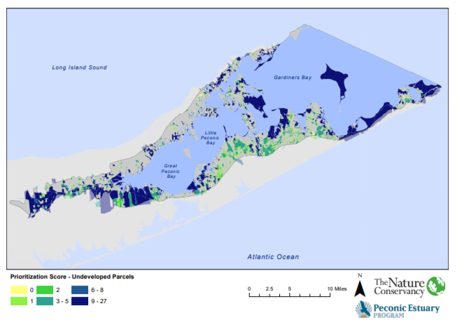
Considering Climate Change in the Critical Lands Protection Strategy
In 2016 PEP embarked on a Climate Ready Assessment (CRA) Project with Anchor QEA, LLC. to incorporate climate change into an updated CLPS, to conduct a risk-based climate change vulnerability assessment, and to develop an adaptation action plan consistent with USEPA’s Climate Ready Estuaries Program. The PEP completed an update to the Peconic Critical Lands Protection Strategy (CLPS), originally completed in 2004, to take into account climate related variables, specifically sea level rise, in order to update land acquisition priorities. This project will result in the protection and acquisition of lands that will help to preserve and improve water and habitat quality in the face of rising sea levels and increased temperatures. It will allow for the natural inland migration of critical wetland habitats as sea level rises and preserve living shorelines in an environment where shoreline hardening is likely to become increasingly common. The information resulting from the new strategy will serve as an important tool for New York State, Suffolk County, and local agencies. The 2019 Critical Lands Protection Strategy is included here in the 2019 Peconic Estuary Partnership Climate Vulnerability Assessment and Action Plan.
The Peconic Estuary Partnership will be sharing this information with the municipalities within the Peconic Estuary watershed. This tool is designed to be continually shared and updated every 5 years.
restoring the Peconic Estuary and its watershed.
Related Content
Climate Change Update July 2012 A summary of potential impacts of climate change in the Peconic Estuary and recommendations for how the Peconic Estuary Partnership can adapt to be prepared to best handle climate change impacts.
Climate-Based Critical Lands Protection Strategy Criteria and Ranking Tool The Critical Lands Protection Strategy (CLPS) Ranking Tool was designed to help decision makers not only decide which lands to acquire, but also evaluate which adaptation strategy is appropriate. See here for the interactive story map.
Connect with Us
Sign up for News, Events and Information straight to your inbox.